The first real snow of November should have felt like a promise of winter. Instead, it felt like a question mark.
Step outside and the air is all wrong. It has weight, but not the crystalline bite we expect this time of year. It hangs low and damp, smelling faintly of wet earth instead of sharp ice. Somewhere far to the north, the Arctic—the planet’s refrigerator—is acting strange again. And that quiet, almost imperceptible wrongness in the air you’re breathing is one of the first ripples.
Far above us, in a sky we rarely think about beyond the shape of clouds, a rare and dramatic atmospheric rearrangement is unfolding. November, usually the season when the polar night tightens its grip on the Arctic, is instead hosting a breakdown—a jarring, early unraveling of the patterns that are supposed to lock cold in place. Meteorologists watching their charts and satellite feeds are seeing signatures they usually associate with deep winter or rare historic events, not with the month that still smells faintly of fallen leaves.
A sky that won’t sit still
The story begins with the jet stream, the invisible river of air that roars high above our heads, guiding storms, shaping seasons, and deciding—on a whim, it sometimes seems—who gets buried in snow and who gets unseasonable rain. In a typical November, that jet stream tightens and strengthens, circling the Arctic like a taut rope. Cold air pools at the top of the world, sealed off by this fast, high-altitude current.
This year, that rope looks frayed.
On weather maps, the jet stream is no longer a neat belt; it is kinking, looping, and stretching. Great bulges of warm air punch northward toward the pole, while tendrils of intense cold spill south. At the heart of this chaos lies the polar vortex, a sprawling whirl of frigid air that usually spins, relatively contained, over the Arctic. Instead of staying compact and centered, it is wobbling and distorting far earlier than usual.
Scientists call this kind of event an “Arctic breakdown”—a disruption of the usual polar patterns that sends cold air roaming and invites warmth into places that should be deep-freezing. What makes this November so remarkable is not just that it is happening, but how it is happening: quickly, dramatically, and with atmospheric fingerprints that hint at rare, deeply entrenched instability high above the planet’s surface.
Listening to the upper air
To understand why this is so unusual, you have to look up—much higher than the clouds you can see. High in the stratosphere, around 20 to 50 kilometers above the ground, a tight, wintertime circulation known as the stratospheric polar vortex usually begins to spin up in late autumn. It’s like a ceiling fan above the troposphere, the layer where our weather lives. When that fan is strong and stable, winter storms tend to behave in familiar ways. When it falters, strange things can happen.
This November, hints of a premature weakening ripple through those upper layers. Waves of energy, generated by mountain ranges, storm systems, and temperature contrasts far below, are breaking upward into the stratosphere with unusual intensity and timing. It’s as if the atmosphere is being rung like a bell from beneath, and the vibrations are already warping the polar circulation before the season has fully settled in.
What makes forecasters lean closer to their screens are the patterns forming in the data: pressure anomalies, temperature spikes at unexpected heights, and sudden distortions in the circulation around the pole. These are the rare signatures—combinations that don’t appear often in the historical record, especially not in early November. They’re atmospheric tells, subtle but insistent, suggesting that the entire vertical column of air above the Arctic is being rearranged.
When the upper vortex weakens or shifts, it often sends signals downward. Over days to weeks, that disruption can translate into a more distorted jet stream, blocking highs that park over continents, or cold air drained like a tilted bowl into middle latitudes. Sometimes that leads to a single intense cold snap; other times, it reshapes a whole winter.
The Arctic, seen from your window
It’s tempting to think of the Arctic as a faraway place of ice and polar bears, a white crown on the globe that rarely touches our daily lives. But this November breakdown is an intimate reminder: the Arctic is not a distant stage; it’s the main gear in the climate machine that turns above us all. When it slips, the effects can be felt in your backyard.
You might notice it first in small ways. Rain where you expected snow. Frost arriving, then vanishing, then returning in sharp, erratic bursts. Storm tracks that feel off-kilter—intense systems slamming into one coast while another region waits under a ghostly, stagnant sky. Across continents, farmers, city planners, and power grid operators quietly retune their expectations, because the reliable patterns they’ve counted on for decades keep fraying at the edges.
This November, the numbers are speaking as clearly as the clouds:
| Indicator | Typical November | This November (Early Breakdown Year) |
|---|---|---|
| Arctic sea ice extent | Slow, steady refreeze; near long-term average | Refreeze delayed; large open-water areas persist |
| Polar vortex structure | Compact, centered over the pole | Distorted, lobes stretching toward mid-latitudes |
| Jet stream path | Relatively zonal, mild waves | Highly wavy; deep troughs and strong ridges |
| Arctic air temperature anomaly | Close to seasonal norms | Several degrees above average over key regions |
| Mid-latitude extremes | Gradual onset of winter conditions | Abrupt cold snaps and unseasonal warmth in neighboring regions |
Each line is a quiet deviation from the script. Together, they tell a story: the Arctic is not just losing its ice; it’s losing its rhythm.
Warmth where the world should be dark
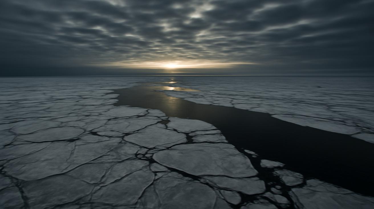
As the sun slips below the horizon for the long polar night, the Arctic ought to cool steadily, radiating heat into space like a vast, dark mirror. Instead, in key regions, the ocean refuses to freeze on schedule. Patches of open water, known as polynyas or delayed freeze-up zones, exhale warmth and moisture into the overlying air. That extra heat feeds into the atmosphere, loosening the delicate balance that keeps the polar vortex stable.
From space, satellites see something almost uncanny: swirling clouds over seas that should already be locked in ice, infrared signatures of warmth bleeding into the upper air. On the ground, in coastal Arctic communities, people walk along shores that still splash with black water instead of meeting a thick, frozen edge. Hunters who once trusted an old calendar of ice now live inside a season that has become unreliable.
This mismatch—between dark, polar night and lingering warmth—is one of the rare atmospheric signatures meteorologists are watching. Another is the pattern of pressure fields stretching like filaments from the tropics toward the pole. Storms born over warm oceans are sending plumes of moist, buoyant air northward, which then rise, cool, and send wave patterns up into the stratosphere. These waves are the invisible levers tugging at the polar vortex, shaking it loose before winter has fully taken shape.
In a sense, the Arctic is being attacked from both below and from the side: ocean heat pushing up, and planetary waves slamming in. The breakdown of its usual order is less a sudden collapse and more a relentless erosion, accelerated this year to a pace that feels startling even to seasoned scientists.
The human weather inside the numbers
Behind every chart of temperature anomalies or jet stream deviations are people adjusting their lives to an atmosphere that has slipped from its old habits. A rancher staring at a forecast of freezing rain where powder snow should fall. A city worker recalibrating salt supplies because ice is forming in stuttering pulses instead of a steady, predictable freeze. A child who can no longer count on a frozen pond by the same weekend they skated on it every year before.
The early November breakdown means winter may arrive in many places not as a gentle slope, but as a series of jolts. Warm spells that coax buds or confuse insects, followed by brutal snaps of Arctic air that descend like a dropped curtain. These swings stress power grids, crops, wildlife, and our own bodies, which are tuned to gradual change more than to whiplash.
Scientists studying these events sometimes talk about “loading the dice”—how a warming world makes certain kinds of extremes more likely. The Arctic is warming more than twice as fast as the global average, a phenomenon known as Arctic amplification. Reduced sea ice, warmer oceans, and shifting snow cover all feed into the atmosphere like extra stories added to a building without reinforcing the foundation. Eventually, that structure doesn’t just creak; it buckles.
This November’s rare atmospheric signatures—the patterns usually reserved for exceptional years—may be another sign that the dice have been not only loaded, but recast.
What a broken Arctic looks like on the ground
So what does an “early Arctic breakdown” actually feel like where you live? The answer depends on where you stand along the twisting path of the jet stream.
Under one of the great northward bulges—the ridges—late autumn may resemble a false spring. Temperatures climb, sometimes smashing records, as warm air from the south pours in and lingers. Skies may turn relentlessly blue, a high-pressure dome locking in dry, mild days that feel pleasant but wrong. Snow that falls refuses to stay, replaced by mud, fog, or drizzle.
Downstream of those ridges, where the jet stream plunges southward into a trough, the story is entirely different. Here, cold Arctic air tumbles down in heavy slabs, meeting moist air from lower latitudes and spinning up powerful storms. Blizzards, ice storms, or intense lake-effect snow can arrive earlier and hit harder than expected. The contrast between neighboring regions—one basking in unusual warmth, another shivering in sudden deep freeze—can be stark enough to trace on a map like a scar.
Wildlife notices, too. Migratory birds may find their traditional stopovers out of sync with food availability. Animals that rely on snow cover for camouflage, like Arctic hares and some species of fox, may turn white against a brown landscape, suddenly visible to predators. Rivers that should be gradually locking into ice instead pulse between freeze and thaw, making travel dangerous for people and animals alike.
This is what a broken Arctic looks like far from the pole: a world in which local weather feels more like mood swings than seasons.
Reading the rare signatures
In weather centers around the world, the drama of this November plays out in silence: banks of monitors, looping satellite animations, columns of numbers scrolling by. Meteorologists look for the rare configurations—the sudden warming in the upper atmosphere above the pole, the split or displacement of the vortex, the long, snaking jet stream lines that refuse to straighten.
They compare what they see now to a handful of past years: winters that began with similar signals and went on to produce infamous cold outbreaks or prolonged regional extremes. But the atmosphere is never a perfect repeat; it is more jazz than sheet music, improvising around familiar themes. So they run their models, day after day, watching how today’s strange November might echo into December and January, knowing that the farther out they look, the fuzzier the picture becomes.
Yet, amid this uncertainty, one thing has become steadily, painfully clear over recent decades: these kinds of disruptions are no longer once-in-a-lifetime oddities. They are becoming chapters in a new, ongoing story of a changing Arctic and a climate system learning new moves.
Living under a restless sky
There is a certain humility that comes from recognizing how intimately your life is bound to places you may never see. Somewhere over the polar ocean right now, the air is moving in ways that will help decide whether you shovel your driveway next month or watch cold rain streak down your windows. The chain that links your evening walk to the shape of the sea ice, the warmth of an open lead, or the wobble of a high-altitude vortex is invisible, but it is real.
We live under a sky that is not just a backdrop, but a living system—responsive, dynamic, increasingly strained. This November’s dramatic early Arctic breakdown is one more sign that the old patterns we built our expectations around are loosening. The refrigerator door at the top of the world doesn’t close as firmly as it once did. Sometimes it hangs open, spilling cold air south. Sometimes it simply fails to chill the way it used to.
In the coming weeks, you may feel the echo of that breakdown in the crunch—or lack—of frost beneath your feet. You might watch a storm charted days in advance suddenly deepen, steered by a jet stream looped like a dropped rope. You may sit in an unseasonably warm patch of sun and sense, beneath the pleasure of it, a sliver of unease.
This is the new conversation between the Arctic and the rest of the world: louder, more erratic, more urgent. We are all listening now, whether we mean to or not.
Frequently Asked Questions
What is an Arctic breakdown?
An Arctic breakdown is a disruption of the usual atmospheric patterns over the Arctic region. Instead of cold air remaining largely confined near the pole, the circulation becomes distorted, allowing warm air to surge northward and cold air to spill south into mid-latitudes. It often involves changes in the polar vortex and the jet stream and can influence weather far from the Arctic.
Why is an early breakdown in November unusual?
In a typical year, the polar vortex and jet stream are still settling into their winter pattern in November. Major disruptions usually occur later in the season. An early breakdown suggests that the atmosphere is becoming unstable sooner than normal, with rare combinations of temperature, pressure, and circulation signatures showing up well ahead of schedule.
How does this affect the weather where I live?
The impacts depend on where you are relative to the distorted jet stream. Some regions may experience unseasonable warmth and dry, stable conditions, while others see abrupt cold snaps, heavy snow, or ice storms. The overall effect is to increase the volatility of weather—bigger swings, less predictability, and stronger extremes.
What role does climate change play in this?
Climate change, and especially the rapid warming of the Arctic, is thought to influence the stability of the polar vortex and the behavior of the jet stream. As sea ice declines and Arctic temperatures rise, more heat and moisture enter the atmosphere, which can weaken or distort the polar circulation. While not every breakdown is caused solely by climate change, the background conditions now favor more frequent and intense disruptions.
Does an Arctic breakdown mean we will have a harsher winter?
Not always. An Arctic breakdown tends to redistribute cold and warmth rather than guarantee universally harsher conditions. Some areas may see severe cold and snow, while others experience milder, stormier, or more variable winters. It increases the chance of extremes but doesn’t dictate a single outcome for every region.
Can scientists predict these events accurately?
Short-term forecasts of Arctic breakdowns and their immediate impacts have improved significantly, thanks to better models and satellite data. However, predicting the full season-long effects remains challenging because the atmosphere is highly complex and influenced by many interacting factors. Scientists can identify higher risks and likely patterns, but not every detail of how the winter will play out.
Is this the new normal for the Arctic?
Patterns like early breakdowns, delayed sea-ice growth, and increased atmospheric instability are becoming more common as the Arctic warms. While there is still natural year-to-year variation, the baseline has shifted. What once would have been considered rare or remarkable is showing up more often, suggesting that a more restless, less predictable Arctic is indeed part of our emerging “new normal.”