The first thing you notice is the color. Not the baked, bone-white glare you’d expect from the edge of a desert, but a soft, improbable green that seems to spill outward from the horizon. The air smells faintly of dust and sap, of damp soil pushing back against the dryness. Somewhere, a tractor rumbles. Children run between skinny saplings, their laughter weaving through the wind. And high above them, hundreds of kilometers overhead, a quiet metal witness in orbit is taking it all in—pixel by pixel, year by year—confirming that this is not a mirage. The desert, for once, is losing.
The Day the Desert Blinked on a Screen
On a pale-blue morning in a mission control room full of coffee mugs and softly humming servers, a NASA scientist clicked between satellite images of northern China. The photos were layered like time-lapse memories: dusty browns from the late 1990s, faint smudges of green creeping in around 2005, and then a deeper, steadier emerald patchiness spreading by the 2010s.
She zoomed in. What had once been a mottled expanse of near-barren land—a landscape frayed by the advancing Gobi Desert—now looked different. There were lines: ribbons of vegetation, darker swaths stretching like veins. It was as though someone had taken a paintbrush to the world’s driest edges and decided that enough was enough.
She leaned back. This was more than reforestation. It was proof of a deliberate gamble: China’s “Great Green Wall” initiative was not just a slogan or a statistic on a planning document. It was visible from space. And NASA’s satellites were confirming that the project was slowing the creeping edge of the desert, reshaping entire regions in silent, patient strokes of green.
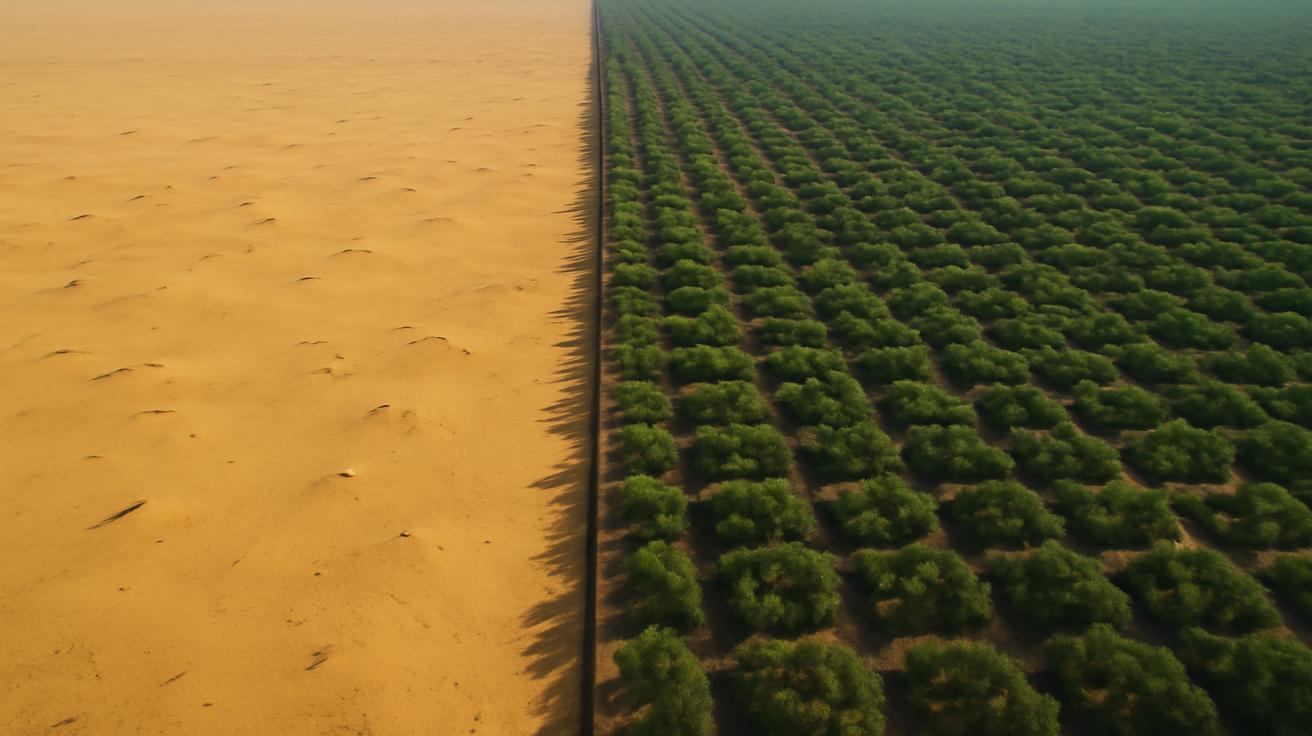
A Wall You Can Walk Through
The Great Green Wall has a name that sounds almost mythical, but it isn’t a single continuous band of forest you could see like a solid blur from orbit. Instead, it’s a mosaic: belts of trees, patches of restored grassland, windbreaks along fields, and carefully managed plots of farmland across northern China. It stretches, in scattered formation, from Xinjiang in the west across Inner Mongolia and Ningxia to Heilongjiang in the far northeast.
On the ground, it doesn’t feel like an epic planetary engineering project. It feels like walking through hard work. Saplings staked against the wind. Irrigation pipes half-buried in sand. Villagers shading their eyes as they look across land that used to be barren and is now stippled with shrubs and low trees.
Where there used to be a kind of resignation—“the desert is coming, and that’s just how it is”—there’s now a stubborn sort of hope. In some villages, dust storms that once turned the sky a sickly yellow several times a year are now rarer, weaker. The soil, once so loose that it lifted at a hint of wind, has begun to knit together as roots push down and organic matter builds up.
The View from Orbit
From above, this change is not romantic but clinical, quantifiable. NASA and other space agencies examine something called “vegetation indices” from satellites like Landsat and MODIS—mathematical translations of how green the Earth’s surface appears, based on the light it reflects. Over time, these numbers tell a story more reliable than memory: where life is taking hold, where it’s thinning, where deserts pause or push forward.
In the data, the northern tier of China is dotted with these upward trends. Areas that once showed declining vegetation now glow with a steadier signal of photosynthesis. The line where the desert once swaggered southward has begun to soften, wobble, and retreat in places. It’s not a perfect, uniform victory—but it’s a clear pattern. In a century defined by environmental bad news, here is a plot twist we can measure.
Desert Memories Carried on the Wind
To understand what it means for a desert to slow down, you have to remember what it looks like when one is on the move.
In the early 2000s, spring in parts of northern China often arrived like a warning. Winds would barrel out of the desert, lifting sand and dust into immense plumes that raced across fields, highways, and towns. The sky could turn from blue to a burning orange in an hour. People taped their windows shut. They wore masks long before pandemics made the rest of the world familiar with the habit. Whole days vanished into grit.
The Gobi and other arid regions had been advancing for decades, driven by a mix of overgrazing, deforestation, and changes in climate. As grasses and shrubs disappeared, nothing remained to pin the soil down. Once the wind had a taste for loose land, it kept coming back. Villages were slowly abandoned. Some towns were literally buried. The desert had a long memory and a clear direction.
A Different Kind of Engineering
China’s answer was not just to plant trees, but to change a relationship with land. The Great Green Wall—launched in the late 1970s and still evolving—set out to reimagine the entire northern frontier as a barrier of life instead of a retreating line of surrender. But this wasn’t a simple matter of digging holes and dropping in seedlings.
Land managers experimented: Which species could survive the punishing climate? How far apart should they be spaced to avoid sucking the soil dry? When should trees be used, and when would grass or shrubs be better? They tried fast-growing poplars, pines, and native shrubs, swapped them out in places where they failed, and tinkered with plantations and mixed-vegetation belts.
Unlike the iconic Great Wall of stone—dead, monumental, singular—this wall had to be alive, adaptive, and willing to fail in some places to succeed in others. And all the while, satellites watched, storing each choice in the language of future maps.
When Pixels Turn Greener: What the Data Shows
NASA’s contribution to this story is not in planting a single tree, but in bearing witness with ruthless honesty. With decades of continuous observation, satellites provide something no single person on the ground can see: scale.
In northern and northwestern China, the data reveals three main changes:
- Vegetation cover has increased significantly in many formerly degraded and desertifying regions.
- The boundaries of certain desert zones have stabilized or even pulled back over recent decades.
- Dust-storm source regions have shrunk, contributing to fewer severe dust events downwind.
This isn’t just NASA’s interpretation; it’s a pattern echoed across multiple studies and independent research teams using different satellites and analytical methods. The “greening” is real. And a substantial portion of it is linked directly to targeted human action—tree-planting, grazing bans in sensitive areas, and restoration projects that knit vegetation back into the landscape.
A Quiet Revolution in the Numbers
If you could zoom in on a single pixel of satellite imagery over a village in Inner Mongolia and watch it over 30 years, it would look like a heartbeat slowly strengthening. At first, the signal of plant life would flicker weakly, spiking a little in wet years and collapsing in dry ones. Over time, as windbreaks are planted and shrubs return, the peak becomes higher, the low points not so low. The heartbeat evens out.
The desert hasn’t vanished, and probably never will. But its most aggressive edges are finding something new in their path—roots, shade, and stubborn human intention.
| Indicator | 1990s Situation | Recent Observations |
|---|---|---|
| Vegetation cover in key northern regions | Declining or very low in many areas near desert margins | Significant increase in many zones, consistent greening trend in satellite data |
| Desert boundary movement | Advancing into cropland and pasture, villages reporting land loss | Stabilization and localized retreat of desert front in restored areas |
| Dust storm frequency and intensity | Frequent severe events, affecting cities hundreds of kilometers away | Overall reduction in many regions, though extreme events still possible |
| Land use around vulnerable zones | Overgrazing, limited protection of fragile soils | Expanded conservation areas, grazing restrictions, structured planting belts |
Life Between the Trees
From a satellite’s altitude, all these efforts compress into colored pixels. But down on the ground, the story is messier, earthier, and deeply human.
Farmers who once watched crops sandblasted away now speak of calmer springs. Windbreaks—rows of poplars or other hardy trees—stand like quiet guardians at the edges of fields. The soil, shaded and shielded, holds a bit more moisture. Yields have improved in some communities, not because the climate itself has become kinder, but because people have renegotiated the terms of their existence with the land.
In some places, older residents remember walking over cracked, powdery earth where now low shrubs buzz with insects. The return of small wildlife is subtle: more birds resting in the saplings, more lizards flicking along stones that once baked unshaded. Children who grew up with dust storms as an annual terror are now more likely to complain about mud after a rain.
Not a Perfect Forest, but a Living One
This is not a fairy tale. Some early phases of the Great Green Wall were criticized, and rightly so. Monoculture plantations—vast stretches of a single tree species—proved vulnerable to pests and drought. Some species gulped water from already-parched soils, doing as much harm as good. In a few areas, trees were planted where grassland would have been a more resilient and ecologically sound choice.
Over time, however, learning seeped in. Planners began to mix species, to favor native varieties and shrubs, to pay more attention to groundwater and local ecology. The wall became less like a rigid line on a map and more like a patchwork quilt, stitched to suit the land beneath it.
NASA’s satellites didn’t see those policy debates or field experiments in real time. But they recorded the outcomes. Areas where poorly chosen plantations withered show up as failures in the data. Regions that adjusted and diversified began to show more durable greening. The landscape itself, as read from space, turned into a record of trial and error.
A Local Wall with Global Echoes
So what does it mean, beyond China’s borders, that the Great Green Wall is working—imperfectly, unevenly, but undeniably—in slowing desert expansion?
For one, it challenges a familiar storyline: that human activity only ever makes ecosystems worse. Here, human hands are responsible for much of the new green spreading along the desert’s edge. This doesn’t erase the pressures of climate change or past degradation, but it complicates the narrative. It says: we aren’t only capable of damage; we’re also capable of repair at enormous scale.
It also offers a kind of living laboratory for other nations facing their own creeping deserts—from the Sahel in Africa to parts of Central Asia and the Middle East. Many of them are launching their own “green walls,” tailored to their climates and cultures. China’s experience, now corroborated from orbit, sends both a warning and an invitation: plant carelessly, and you risk wasted effort and thirsty, failing forests; plant thoughtfully, and you might literally redraw your maps.
The Climate Connection
There’s another layer, too. Greener land surfaces influence local climate conditions: they can cool the ground, change how moisture cycles between soil and sky, and store more carbon in trunks, roots, and soil. While the Great Green Wall alone won’t solve global warming, it’s part of a broader shift that matters.
In a warming world, deserts are expected to expand in many regions. But the data from northern China offers an intriguing counterpoint: under certain conditions, with enough political will and long-term persistence, the trend can be bent, at least locally. The desert’s march is not destiny; it’s a negotiation.
That negotiation isn’t simple. Some areas will remain too dry or fragile for dense forests. Climate extremes—heatwaves, prolonged drought—will test every sapling. But in the back-and-forth between sand and leaf, the existence of a contest at all is hopeful.
What the Satellites Can’t See
There’s an irony in how we know so much about this story. Instruments floating in the vacuum of space, far removed from the smell of wet soil or the sting of blowing sand, are among our most trusted narrators about what’s happening down here. They scan, record, and send back streams of numbers that become maps, charts, and headlines.
But they can’t see the expressions on the faces of the people whose lives are intertwined with these changes. They don’t know what it feels like for a child in a northern village to see a tree older than they are and realize that its presence is not an accident but a kind of promise—that someone decided, decades ago, that the horizon should stay where it is.
In a village that once sat in the shadow of encroaching dunes, a man might lean on his shovel and watch the wind comb through a line of young poplars. He might still worry about the next drought, about market prices, about his children leaving for cities. But there’s one less thing to fear: the idea that the land beneath him is slipping inevitably away.
NASA’s satellites confirm the arc of this story, but the meaning of it resides in these quiet, ground-level moments. In hands cracked from planting. In the thrill of a first shade under a tree where, a decade ago, there was only glare.
Looking Forward: A Wall That Must Keep Growing
The Great Green Wall is not finished; it may never really be. Trees die. Policies shift. Climate patterns keep changing. A few consecutive dry years could reverse some gains. Overgrazing could return if regulations loosen. In other words, this isn’t a victory to be framed and hung on a wall—it’s an ongoing practice.
The satellites will keep watching. Each new pass will add another page to the time-lapse story, another layer to the memory of the land. If the greening trend continues—if belts of forest and shrubland deepen and diversify, if soils stay anchored—it will become harder and harder to argue that deserts at the margins of human settlement are untouchable forces.
And maybe that’s the quiet revolution here. For centuries, deserts have been symbols of inevitability, of nature’s harshness and human smallness. NASA’s images of China’s northern frontier tell a different kind of tale: one in which the line between sand and green is not a foregone conclusion, but a conversation carried out in roots and policy, in windbreaks and satellite orbits.
Stand again on that edge where green meets gold. Close your eyes and listen. You can still hear the desert in the wind, old and patient. But you can also hear something else: the rustle of leaves that were never supposed to be there, the murmur of a landscape that has decided, with our help, to answer back.
Frequently Asked Questions
Is the Great Green Wall in China actually visible from space?
Individual tree belts or forests are generally too small to pick out with the naked eye from orbit, but their combined effect is absolutely visible in satellite data. NASA and other agencies detect large-scale changes in vegetation cover over northern China, confirming a broad “greening” trend linked to the Great Green Wall and related restoration projects.
Has the project completely stopped desertification?
No. Desertification is complex and ongoing, driven by climate change, land use, and water availability. However, satellite observations show that in many targeted areas, desert expansion has slowed, stabilized, or even reversed. The project reduces the pace and extent of land degradation rather than eliminating it entirely.
Does tree planting ever cause problems in these dry regions?
Yes. Early phases sometimes used water-hungry or non-native species, or planted dense monocultures. In some locations this stressed groundwater, led to tree die-off, or reduced biodiversity. Over time, planners have increasingly shifted toward more diverse, locally adapted species and a mix of trees, shrubs, and grassland restoration.
How do NASA satellites measure “greening”?
Satellites detect how Earth’s surface reflects different wavelengths of light. Vegetation has a unique signature, especially in the red and near-infrared parts of the spectrum. Scientists use indices like NDVI (Normalized Difference Vegetation Index) to track how much healthy plant cover exists in a given area over time.
Can other countries copy China’s Great Green Wall model?
Elements of the approach—long-term planning, large-scale restoration, and the use of satellite monitoring—are transferable. But each region must adapt the idea to its own climate, soils, and culture. Projects in Africa, for example, often emphasize drought-tolerant native shrubs, assisted natural regeneration, and agroforestry rather than dense tree belts alone.
Is this project important for climate change mitigation?
The Great Green Wall contributes by storing carbon in vegetation and soils and by improving local climate resilience. It won’t solve global warming on its own, but it’s part of a broader toolkit of land-based climate solutions that, together with emissions cuts, can help stabilize the climate.
Will satellites continue to monitor the progress of the Great Green Wall?
Yes. Ongoing missions like Landsat, MODIS, and newer satellites will keep providing time-series data for northern China. This continuous record allows researchers to track successes and setbacks, refine restoration strategies, and understand how changing climate conditions interact with human efforts on the ground.