The first sign that something strange is happening isn’t on a satellite map or a weather model. It’s in the air itself. The cold feels different—sharper, more insistent, as if every breath carries a warning. Streetlights glow in a halo of ice crystals, and car tires hiss over pavement dusted with the fine powder of an early snow. Somewhere, high above all of this—twice as high as the cruising altitude of a jetliner—the atmosphere is rearranging itself in slow, powerful spirals. A polar vortex disruption is brewing, and for once, the term isn’t just an overused headline. It’s the kind of event that makes forecasters pick up the phone, call transportation authorities, and say, plainly: “You need to be ready for things to stop.”
When the Sky Comes Undone
To understand why meteorologists sound tense when they talk about this winter’s evolving pattern, you have to go up—far above the familiar clouds, beyond the roaring jet stream that shuttles storms from west to east. Up there, in the stratosphere, sits a vast, whirling pool of cold air: the polar vortex. In a typical winter, it spins like a well-balanced top, keeping most of the truly brutal cold locked near the Arctic.
But this time, the top is wobbling.
In the highest layers of the atmosphere, waves of energy—triggered by sprawling weather systems over the continents and the Pacific—are pushing and poking at the vortex. Imagine a spinning bowl of water disturbed by invisible hands. The vortex stretches, buckles, and, in the most dramatic events, splits outright. That’s the kind of disruption models are hinting at now: not a minor nudge, but a structural blow strong enough to send shock waves cascading downward into the weather we feel at ground level.
The process is eerily slow. A sudden stratospheric warming event—the technical name for the disruption—can begin with a rapid temperature jump tens of miles above the surface. Up there, air that was brutally cold can warm by 30 or 40 degrees Celsius in just a few days. This warming doesn’t mean cozy weather for us. It means the vortex, deprived of its icy spine, begins to unravel. Its winds weaken. Its boundaries become porous.
Below, in the world of airports, highways, and train tracks, the atmosphere waits. The jet stream takes its cues from that high-altitude chaos. Over the course of one to three weeks, the ripples from the disrupted vortex propagate downward, twisting the storm tracks, sometimes bending the jet stream into absurd, plunging loops. That’s when Arctic air, once neatly corralled, spills south like water from a broken dam.
Cold That Redraws the Map
When forecasters talk about “widespread travel paralysis,” they’re not being dramatic. They’re doing the grim arithmetic of what happens when air that belongs in the high Arctic settles over busy transport corridors—interstates, shipping hubs, rail yards, and airport tarmacs—already running near capacity.
Picture a long-haul trucker on a midnight interstate run. The road ahead is a thin gray ribbon swallowed by a curtain of white. Snow isn’t just falling; it’s blowing sideways, driven by a wind that gusts to 40 miles an hour. Every passing semi throws a blinding plume across the windshield. Yes, the truck can keep moving, but every mile becomes a risk, every bridge deck a potential sheet of black ice. Multiply this scene by thousands of rigs, buses, and family sedans, and you start to see how a continent-wide cold wave can slow a whole economy.
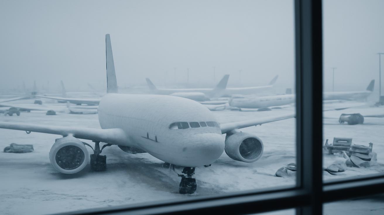
At the same time, hundreds of flights stack up in the departure board grid of a major hub. Ice clings to wingtips and elevators. Deicing trucks glow orange in the pre-dawn gloom, hissing glycol over aircraft skins that freeze over again minutes later in the relentless wind. Runway crews race a clock they know they can’t beat: snow rates so intense that plows can’t keep up, crosswinds that exceed safe landing limits, visibility dropping in sudden whiteouts. Control towers start rerouting, then holding, then canceling. One storm, timed badly, can send shock waves through flight schedules for days. A polar vortex disruption that reshapes the storm track for weeks? That’s another level entirely.
On the rail lines, metal becomes brittle in the deep cold. Switches freeze. Air brake lines stutter and fail when moisture inside them turns to ice. Trains move more slowly or not at all. Freight that was supposed to glide through a sleek just-in-time network sits motionless in yards turned into frozen labyrinths. Even urban transit systems—designed to shrug off winter—can falter when temperatures plunge below their design thresholds, tracks contract, and power systems grind under the weight of emergency heating demand.
The Anatomy of a Deep Freeze
The current disruption isn’t just about one epic blizzard. It’s about the choreography of cold, wind, and timing across an entire continent. Meteorologists, sifting through ensemble model runs, see the same uneasy pattern: a disrupted vortex that may send repeated pulses of Arctic air into mid-latitudes, each surge interacting with moisture and local terrain in different, sometimes surprising ways.
A bitter high-pressure dome can slide south and park stubbornly over the interior, like a block of ice lodged in the atmosphere itself. Around its edges, storms are forced to detour, grinding through corridors already stressed by snowpack and ice. Lakes that had been open water days earlier churn into steam, feeding squall lines that drop snow in absurd, localized amounts—four inches here, twenty inches a few miles away—depending on where the wind and shorelines align. Mountain passes become chokepoints, where a single jackknifed truck or stranded bus can leave hundreds of travelers trapped in still, idling vehicles as the mercury plunges hour by hour.
All of this is why forecasters are quietly, insistently raising the alarm. It’s not only about how cold it could get, or how much snow may fall, but about how long the pattern could lock in—and how unprepared many of our systems are for a sustained atmospheric siege.
The Human Weather Inside the Storm
Weather maps, with their swirling blues and purples, can’t capture the feeling of a city bracing for a polar vortex disruption. You feel it in the grocery store line, carts heavy with canned soup and rock salt. You feel it in the slightly higher pitch of the local meteorologist’s voice, the nervous joke about “maybe work from home if you can.” You feel it when your phone pings with yet another advisory: winter storm watch, wind chill warning, hazardous travel outlook.
At a small regional airport, the first cancellations come early. A commuter flight from a larger hub is scrubbed because the incoming plane never left Chicago. Passengers cluster around the gate, clutching boarding passes that have suddenly become small, rectangular question marks. Somewhere in the terminal, a child presses their nose against the glass, watching snow snakes trail across the tarmac. Out on the runway, workers in reflective coats lean into a wind so cold it bites through their multiple layers within minutes. The radios crackle: “We’re going to start shutting down.”
In the city, plow drivers grab quick naps in their trucks between runs. The orange glow of their flashing lights becomes the heartbeat of the night, pulsing down buried streets. At intersections, pedestrians shuffle carefully, boots seeking friction on ice-slick crosswalks. The wind funnels between buildings, turning every corner into a surprise. It smells like metal and snow and, occasionally, like wood smoke from someone’s stubbornly old-fashioned fireplace.
On the highways leading out of town, the atmosphere feels strangely muffled. Traffic thins, then almost disappears. Those who do venture out carry blankets and extra water, perhaps remembering the stories from past vortex events, when entire stretches of interstate turned into frozen parking lots and rescuers moved from car to car checking for people in need of warmth or fuel.
How Forecasters See What’s Coming
In quiet, windowless rooms, meteorologists watch the upper atmosphere in high-definition. They track the strength of the polar vortex with a handful of cryptic numbers: zonal wind speeds at 10 hPa, temperature anomalies at 60°N latitude, geopotential height patterns that most people will never see or understand. To them, the atmosphere is less a backdrop than a living ocean, full of waves and countercurrents. When those stratospheric winds slow, when their direction threatens to reverse, alarms go off—not literal sirens, but the internal kind that develop after years of matching model output with what eventually happens on the ground.
This winter, those alarms are ringing. Forecast ensembles—multiple runs of complex weather models, each with slightly different starting conditions—agree more than usual. That agreement matters. It tells forecasters that they’re not chasing a phantom. The odds rise that somewhere between ten and twenty days after the disruption peaks, cold will spill southward in earnest. Not everywhere will be equally affected; that’s where geography, ocean temperatures, and myriad smaller patterns come into play. But the broad brushstrokes say: expect extremes. Expect the unexpected.
They also know the limitations. No model can tell a highway patrol officer which bridge will ice first, or a small-town mayor exactly when the snow will transition to sleet and back again. But they can say, with increasing confidence, that travel will be dangerous over vast areas, and that the usual winter coping mechanisms—a bit more salt, an extra plow shift—won’t be sufficient.
Preparing for a World That Might Pause
“Widespread travel paralysis” is a cold phrase for something deeply human: the sudden stillness that comes when people decide, or are forced, to stay put. It starts with small choices—a meeting moved online, a postponed visit, a rescheduled delivery—and gradually scales into something more profound. School buses stay in their lots. Commuter trains sit empty at platforms. The hum of a city shifts as fewer engines turn over in the morning, replaced by the soft, granular sounds of boots in snow and shovels on sidewalks.
The magnitude of the coming disruption has triggered a specific kind of urgency among planners. Highway departments are evaluating salt supplies and contractor rosters. Airlines are modeling schedule reductions before the worst of the weather hits, painful but calculated decisions that can prevent an even more chaotic cascade of delays and diversions. Rail operators are inspecting critical switches, testing heaters, shoring up vulnerable segments before they’re buried or frozen.
For individuals, preparation is less technical but no less important. The basics suddenly matter again: a full tank of fuel, a flashlight that works, enough food and medications to stay home for a few extra days. A small travel bag with thermal layers and a power bank, in case a journey that should have taken two hours stretches into eight. The old advice your grandparents muttered about never traveling in winter without a blanket in the car? In a year like this, it lands differently.
| Aspect | What to Expect | How to Prepare |
|---|---|---|
| Air Travel | Frequent delays, ground stops, extended deicing, mass cancellations at hubs | Fly earlier when possible, pack essentials in carry-on, be flexible with dates and routes |
| Road Travel | Whiteout conditions, black ice, stranded vehicles, highway closures | Delay nonessential trips, carry winter kit (blanket, food, water), reduce speed dramatically |
| Rail & Transit | Frozen switches, slower speeds, cancellations on some lines | Check status before leaving, allow extra time, have backup routes |
| Home & Power | Potential outages, stressed heating systems, frozen pipes | Insulate pipes, have backup heat and lighting, stock basic supplies for several days |
There’s a quiet solidarity that emerges in times like this. Neighbors check on each other more than usual. A text pops up: “You okay over there? Need anything?” A snowblower is shared, a driveway cleared for the older couple who can no longer shovel. The paralysis of movement makes the circles of care smaller, more intense, but also more visible. When travel grinds to a halt, people rediscover the immediate geography of their lives: the people within walking distance, the corner store that stayed open, the warm room where everyone eventually gathers to wait out the wind.
The Bigger Story in the Ice
Behind this single disruptive event lies a larger question that scientists are still working to answer: what does a warming world mean for the behavior of the polar vortex itself? Counterintuitively, some research suggests that rapid warming in the Arctic, and loss of sea ice, can destabilize the patterns that once kept the cold bottled up. In that view, the atmosphere is a system trying to redistribute energy and temperature more evenly—sometimes overshooting, sending lobes of brutal cold deep into regions unaccustomed to sustaining it.
Not every year brings a major vortex event. Not every disruption causes the same kind of chaos. But the pattern is enough to make climatologists and meteorologists talk more to one another than they used to, connecting individual winters to broader trends. Are we entering an era where winters are shorter on average, but punctuated by more violent outbursts of cold? Can our infrastructure adapt to swinging between record warmth and record cold within the span of a few weeks?
For now, those questions remain partly open. What is clear is that our sense of what is “normal” winter weather is fraying. A polar vortex disruption of this magnitude doesn’t just change travel plans; it challenges assumptions about what roads, rails, airports, and power grids were built to withstand.
Living Inside the Forecast
As the days tick down to the expected arrival of the worst cold, the forecast becomes less abstract and more like a script everyone is quietly rehearsing. Weather apps glow on nightstands. Parents make contingency plans for school closures. Logistics managers stare at maps dotted with warehouses, knowing that a delayed truck in one snow-choked city can ripple outward, emptying shelves hundreds of miles away.
Outdoors, you may notice how the world sounds different as the deep cold nears. Snow underfoot goes from soft and squeaky to brittle, almost hollow. The air feels thinner, each inhalation scraping a little at the back of your throat. The sky takes on a particular metallic brightness on the coldest days, the sun shining hard but giving so little warmth that your exposed skin stings within minutes. The weather is no longer background noise; it is the main story, and you are inside it.
There is something humbling in that. In a world where so much feels digital, abstract, and distant, a polar vortex disruption is stubbornly, viscerally real. You can’t negotiate with it or ignore it into submission. You plan, you adapt, you wait. You notice how dependent movement has made you feel, and what it means when, suddenly, staying still becomes the wisest, safest choice.
Somewhere above, in the thin air of the stratosphere, the broken vortex will eventually begin to heal. Winds will strengthen again, temperatures will settle back toward their frigid norms, and the jet stream will respond, straightening ever so slightly. On the ground, the ice will melt from the runways and the highways. The travel paralysis will ease. Flights will depart with only the usual delays. Trains will run on time again. But for a while, the memory will linger: the eerie calm of a city muffled in snow, the quieting of roads and skies, the realization that the atmosphere still holds the power to stop us, together, in our tracks.
And perhaps, the next time someone mentions the polar vortex, it won’t sound like just another piece of jargon. It will sound like a reminder that above the maps on our screens, the air is alive—capable of reorganizing itself in ways that reach all the way down to the simple question: can we get from here to there today?
Frequently Asked Questions
What exactly is a polar vortex disruption?
A polar vortex disruption happens when the normally strong, circular winds around the Arctic in the stratosphere weaken, wobble, or even split. This is often triggered by waves of energy rising up from the lower atmosphere. When the vortex is disturbed, it can send very cold Arctic air southward into regions that don’t usually experience such intense, prolonged cold.
Why can this cause “widespread travel paralysis”?
When Arctic air spills south, it can create extreme cold, heavy snow, strong winds, and ice over very large areas. Roads become hazardous or impassable, airports struggle with deicing and low visibility, and rail systems face frozen switches and equipment issues. Because modern transport networks are so interconnected, disruptions in a few key hubs can ripple outward, slowing or stopping movement across entire regions.
How far in advance can forecasters see a polar vortex disruption coming?
Meteorologists often detect early signs of a disruption in the stratosphere one to three weeks before its full impact reaches the surface. They use ensemble weather models and measurements of upper-level winds and temperatures to track how the disturbance might cascade downward and alter surface weather patterns.
Will every polar vortex disruption bring extreme cold to my area?
No. While a major disruption increases the chances of severe cold somewhere in the mid-latitudes, the exact locations depend on how the jet stream and pressure patterns realign. Some regions may see only modest changes, while others get locked into prolonged cold, snow, or ice. Local forecasts closer to the event are essential.
What can individuals do to prepare for this kind of event?
Delay nonessential travel during peak storms or extreme cold, keep a winter emergency kit in your vehicle, and ensure your home is ready for possible power outages and deep freezes (insulated pipes, backup light and heat, basic food and medications). Staying informed through reliable weather updates and being flexible with plans are key parts of staying safe.