The sky over the northern hemisphere has been doing something strange lately, and most people walking down a city street, coffee in hand, have no idea. The air feels oddly gentle for January in many places, a kind of hesitant winter, as if the season itself can’t quite decide who it wants to be. But high above all that quiet confusion, more than 30 kilometers over our heads, the atmosphere is bracing for an upheaval. A polar vortex disruption is coming—big, unruly, and so powerful that even seasoned scientists are blinking twice at the simulations. This isn’t just another cold snap story. It’s the tale of how the invisible machinery of winter is about to grind, lurch, and possibly send shockwaves down to where we live, walk, shovel, and breathe.
The invisible engine over the Arctic
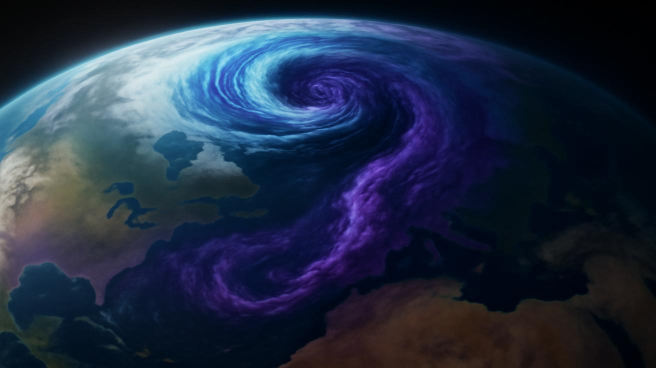
Picture the Arctic night in January: a vast, dim dome of darkness, sea ice cracking softly, winds whispering and howling over a frozen ocean. We tend to imagine Arctic weather as something that stays politely in its lane, locked up near the pole. But sitting above that icy stillness is a colossal engine of air, moving in circles, day after day: the polar vortex.
The vortex isn’t a single storm or a monster cloud you can point to on a weather map. It’s a broad ring of strong westerly winds in the stratosphere, far above the clouds we watch and the planes we fly in. Up there, winter takes on a different character. Temperatures plunge to levels that defy intuition, and the sun barely rises. In this high, thin air, the vortex spins like a gyroscope holding the seasons in balance.
When it’s strong, the polar vortex keeps the rigor of Arctic winter bottled up to the north. It corrals ferocious cold, locking it over the polar regions like a lid on a freezer. Mid-latitude cities—from Chicago to Berlin to Tokyo—tend to enjoy relatively organized patterns: maybe a steady march of storms, maybe ordinary cold spells, but nothing utterly chaotic. A strong vortex usually means winter has its rules.
But that invisible order is fragile. Every so often, the vortex staggers. Planetary waves—huge, undulating bulges in the atmosphere driven by mountains, land–sea contrasts, and sprawling weather systems—surge upward from the troposphere and crash into the stratosphere. It’s a bit like ocean swells slamming a spinning top. If the waves are strong enough, they can weaken, wobble, or even split that top apart.
When the sky suddenly warms
In the language of atmospheric science, what we’re heading into is called a sudden stratospheric warming, or SSW. It sounds gentle, but it is anything but. In a matter of days, temperatures in the polar stratosphere can rocket upward by 30, 40, even 50 degrees Celsius—without ever becoming what we’d call “warm” in human terms, but still a shocking transformation for that rarified realm.
Down at the surface, we don’t feel that heat. We feel the consequences. The vortex’s protective ring of winds falters. Sometimes it elongates, like taffy being pulled. Other times, it splits into two distinct swirls that drift away from the pole. The Arctic cold that had been tidily confined begins to leak outward, sagging into the continents in tendrils and lobes. The jet stream, the powerful river of air higher in the troposphere that steers our storms, starts to buckle and twist.
Most winters offer a few signs of this drama, small nudges that shake things up for a week or two. But the disruption taking shape now is on an entirely different scale. The magnitude of the projected warming and wind reversal is, by January standards, almost unheard of. Models are painting the kind of picture that makes atmospheric scientists sit a little straighter in their chairs.
Think of the polar vortex as a carefully spun glass bowl suspended above the pole. This event isn’t just a tap on the rim; it’s more like someone has swung a hammer at it. The stratosphere over the Arctic is poised to flip its script—from bitterly cold with strong westerly winds to comparatively mild with winds that may actually reverse direction and blow from east to west. For a time, the flow at the top of the winter hemisphere may quite literally run backward.
January is not supposed to look like this
It’s not that sudden stratospheric warmings are rare. They happen roughly every other winter on average. Some of the most notorious cold outbreaks in recent decades—the ones that carpeted North America or Europe in snow and collapsed power systems across regions—have traced their lineage back to an SSW a few weeks earlier. But what sets this event apart is the timing and intensity.
January is traditionally when the polar vortex flexes its muscles. By then, the Arctic has been in the dark long enough to cool brutally. The vortex, fueled by those intense temperature contrasts, tends to be near its seasonal peak. It’s the month when the atmospheric top should be spinning fastest and strongest, not faltering.
And yet, here we are, with forecasts showing a warming in the polar stratosphere so intense that temperature anomalies—departures from normal—look like a blotch of crimson bleeding across the top of the world. Winds that usually roar with near-unbreakable strength look set to weaken dramatically or even flip. In the archive of January events, an episode of this potential magnitude sits near the outer edge of what we’ve recorded.
Part of what makes this so captivating is the dissonance between what many people are experiencing and what’s coming. In some regions, winter has felt oddly shy so far, more like an extended November than a bruising January. The air has had a softness to it, a hesitance. People sip their coffee outdoors, a little baffled but not complaining.
All the while, energy has been building quietly above—the way a river swells upstream long before you see the flood. Planetary waves from storms over the North Pacific, or from the bulging landmasses of Eurasia, have been moving upward and inward, setting the stage. Soon, in the cold dark over the pole, the atmosphere will revolt against its own routine.
From the stratosphere to your front door
The most common question—posed over office desks, in school hallways, on late-night call-in radio shows—is deceptively simple: “So what does this mean for us?” The honest answer is that even with all our satellites, supercomputers, and expertise, there’s no single, clean forecast card that falls out of an event like this. What the polar vortex does in the stratosphere is a powerful nudge, not a fixed script.
After a major SSW, it usually takes one to three weeks for the reverberations to travel down through the atmosphere. Think of it as a slow-motion domino effect, where each layer of air rearranges itself slightly, passing that rearrangement downward. By the time those changes touch the jet stream and the weather systems directly above our heads, the result is often a shift toward more blocked patterns.
“Blocked” is meteorologist shorthand for a stubbornness in the flow. Instead of storms sweeping briskly from west to east, you get ridges and troughs—bulges of warm air and plunges of cold—that get stuck. A region might spend days or weeks under a persistent high-pressure dome with stagnant, dry, or smoggy conditions. Elsewhere, cold air may pool and refuse to budge, turning routine chill into a grinding freeze.
Many of the bitter cold spells remembered for decades—streets glassed in ice, power lines shuddering under frost—owe their existence to these disrupted, blocked patterns. The coming event greatly increases the odds of that kind of setup somewhere across the northern mid-latitudes in the weeks that follow. Not everywhere will turn frigid; some places may even see milder or stormier weather as the atmosphere’s energy redistributes. But the dice are being heavily loaded toward extremes.
The tangible impacts depend on where those kinks in the jet stream set up shop. If a deep trough carves south over North America, Arctic air could plunge into the U.S. or Canada, challenging energy grids and painting frost on windows from the Plains to the East Coast. If Europe ends up under the crosshairs, the continent could trade its recent bouts of mildness for snow-laden skies and biting winds. East Asia too sits on the front lines of these rearrangements; past SSWs have helped unleash severe cold there as well.
| Region | Potential Outcome After Strong SSW | Key Concerns |
|---|---|---|
| North America | Increased risk of Arctic outbreaks, especially central and eastern areas | Energy demand spikes, transport disruption, power grid stress |
| Europe | Greater odds of prolonged cold, snow events, or blocking highs | Heating needs, travel disruption, impacts on agriculture |
| East Asia | Potential for severe cold spells and heavy snow in some areas | Infrastructure strain, health risks, industrial interruptions |
| Arctic | Relative warming aloft, altered sea-ice and surface temperature patterns | Ecosystem shifts, feedbacks into future weather patterns |
The irony is sharp: the stratosphere warms dramatically, while some of us may shiver harder at the surface. That disconnect is part of what makes the atmosphere such a subtle, shape-shifting system. Warmth in one layer can help unlock cold in another, just as a crack in river ice upstream can send a floe surging into a quiet bend downstream.
Living under a broken pattern
If you’ve ever lived through a winter that seemed to freeze time itself—a month when the sky kept recycling the same low gray clouds, the same biting wind from the same direction, the same creeping drifts along the roadside—you’ve lived under a blocked pattern. The days become a kind of loop. The calendar turns, but the weather does not.
These are the winters of improvised snowplow routes, of school cancellations tacked up day after day, of grocery store shelves thinning a little as supply trucks struggle. They’re also the winters that create their own odd intimacies: neighbors helping shovel each other’s driveways, kids learning the shape of every icicle along the eaves, the sound of boots thumping in mudrooms like a background drumbeat to daily life.
If the looming polar vortex disruption plays out as strongly as projected, many communities may find themselves back in that suspended state—in cold, in storminess, or in stuck-without-storms dryness. The flavor of it will vary, but the common thread is persistence. Instead of a winter of constant variety, we may be heading into an act with a single, insistently repeated theme.
There’s a psychological dimension to this that rarely makes the forecast maps. Our moods often track the weather more closely than we admit. Extended gray and cold can press on people prone to seasonal affective disorder. Prolonged storms can fray nerves and schedules. But they can also slow things down, forcing us to measure days not just by emails and meetings, but by the height of the snowbank and the rattle of sleet against the window.
Climate change’s quiet fingerprints
Hovering behind any large atmospheric anomaly now is the bigger, slower question: how much of this is just the old natural rhythm of the planet, and how much is subtly tuned by the warming we’ve unleashed? On the surface, a polar vortex disruption sounds like a story of cold, not heat. But step back, and the two are not so easily disentangled.
The Arctic is warming faster than almost anywhere else on Earth. Sea ice is thinner, younger, and more fragile. Open water in autumn pumps extra heat and moisture into the lower atmosphere. Snow cover patterns on the great northern continents are shifting. All of these changes alter the waves that ripple through the atmosphere and ultimately buffet the polar vortex.
Scientists are still arguing, testing, refining. Some studies suggest that a warmer Arctic may be linked to more frequent or more intense disruptions of the vortex, increasing the odds of extreme cold outbreaks in mid-latitudes even as the planet warms overall. Others urge caution, pointing to the tangled nature of atmospheric variability and the limited length of our observational records. What is clear, though, is that we are no longer living in the same background climate in which earlier SSWs played out.
It’s like listening to an orchestra that has slowly retuned itself. The melody—the seasonal swing from summer heat to winter chill and back again—is still recognizable. But the harmonies, the subtle interactions between ocean, ice, and atmosphere, are shifting. When a polar vortex event arrives in this altered context, the outcome can surprise us, even if the broad outlines are familiar.
How to read the sky in the weeks ahead
So how do you live through a season whose script is being re-written high above your head? One way is to pay a different kind of attention. Watch not just the daily forecast, but the evolving patterns: Does the jet stream seem stuck over your region? Are storm tracks repeating? Are cold or mild spells lingering longer than usual?
For those who manage infrastructure—power grids, transportation networks, emergency services—this is the time to treat “normal” as a poor guide and to lean into flexibility. A major polar vortex disruption doesn’t guarantee catastrophe, but it does raise the stakes. A cold wave that might have been a footnote in a typical winter can strain systems already stretched by other stressors, from aging equipment to high demand.
On a more personal level, this is a moment to reacquaint yourself with winter as something alive and dynamic, not just a backdrop. If you live in a region likely to see strong effects, simple, practical steps matter: ensuring homes are well insulated, cars are winter-ready, and vulnerable neighbors have what they need if conditions turn harsher. Preparedness isn’t alarmism; it’s respect for the complexity of the world we inhabit.
And there is, even in the risk, a strange beauty to what’s unfolding. The atmosphere is about to demonstrate, on a grand scale, just how interconnected everything is—from the rough topography of distant continents to the swirl of winds over the Arctic to the frost patterns on your bedroom window. The same planet that delivers spring blossoms and autumn light also casts its weight through these vast, invisible motions of air that we only glimpse in their consequences.
Listening to the planet’s deep machinery
Over the next few weeks, satellites will watch as temperatures surge tens of degrees in the polar stratosphere. Radiosondes—weather balloons launched from icy runways and quiet fields—will rise through the night, sampling the changing winds. Supercomputers will spin out thousands of different possible evolutions, exploring where the tug-of-war between waves and vortex might lead. And on the ground, most people will simply look out the window and decide whether they need a heavier coat.
That gap—the space between the grand, intricate processes swirling above and the ordinary choices of daily life—is where this story really lives. A polar vortex disruption is not just a headline about “extreme cold” or another graphic on an evening weather report. It’s a reminder that the air around us is part of a living system, one whose scales of motion stretch from the gust that rattles your door to the sprawling wind fields circling a pole you may never see.
To know that something almost unprecedented for January is unfolding overhead is to be invited into a deeper kind of awareness. You might find yourself stepping outside at night and feeling the stillness differently, imagining the high atmosphere in upheaval far above. You might feel the bite of a future cold wave and, instead of shrugging it off as random, recognize it as an echo of that distant stratospheric flip.
We live our lives in a thin slice of air near the ground, but our fates are braided into much higher currents. This winter, those currents are shifting—suddenly, powerfully, and in ways that will ripple through our maps and memories. The polar vortex is about to falter. The sky is about to tell a louder story. The question now is how carefully we listen, and how wisely we respond.
Frequently Asked Questions
What exactly is the polar vortex?
The polar vortex is a large-scale circulation of strong westerly winds high in the stratosphere over the Arctic (and a similar one over Antarctica). It forms every winter when polar regions grow much colder than lower latitudes. When it’s strong, it tends to keep Arctic air locked near the pole.
What is a sudden stratospheric warming (SSW)?
A sudden stratospheric warming is a rapid rise in temperatures in the polar stratosphere, often by 30–50°C over a few days, accompanied by a weakening or reversal of the usual westerly winds. This disruption often weakens or splits the polar vortex and can impact weather patterns weeks later.
Does a polar vortex disruption always mean extreme cold where I live?
No. A strong disruption increases the chances of unusual or extreme patterns, including severe cold in some regions, but not everywhere. Some areas may experience milder conditions, storms, or dry, stagnant weather instead. The exact outcome depends on how the jet stream rearranges.
How long after an SSW do we feel the effects at the surface?
Typically, it takes about 1–3 weeks for the impacts to propagate downward from the stratosphere to the troposphere, where our day-to-day weather happens. The resulting patterns can then persist for several weeks.
Is climate change causing more polar vortex disruptions?
Scientists are actively researching this. Some studies suggest that a warming Arctic and changing snow and ice patterns may be linked to more frequent or intense disruptions, while others highlight large natural variability and uncertainty. What’s clear is that these events now unfold in a warmer, altered background climate.
How can I prepare for potential impacts from this event?
Stay informed through local forecasts in the coming weeks, as they will reflect any developing extreme patterns. Make sure your home is ready for possible severe winter weather: check heating systems, winterize vehicles, prepare basic supplies, and look out for vulnerable people in your community.
Why is this particular January disruption considered so unusual?
The projected magnitude of warming and wind reversal in the polar stratosphere is near the upper end of what has been observed in January. January is typically when the vortex is strongest, so a disruption of this intensity at this time of year stands out in the historical record.