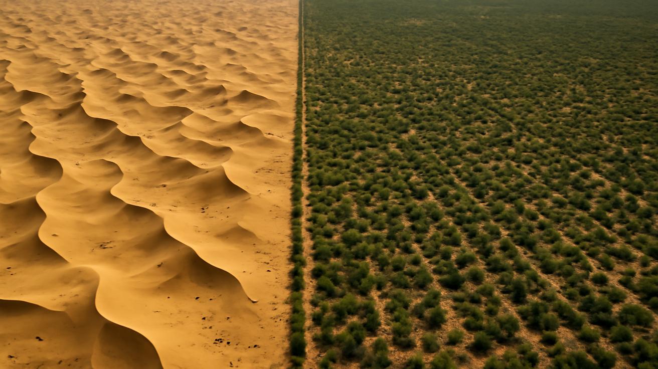
The first time you see it from orbit, it looks like a rumor made visible: a faint, brushed-green arc edging the ochre sweep of northern China. From high above, the deserts are clean geometry—vast dun-colored fans and wind-raked dunes. But running along their border is something that wasn’t there a few decades ago, a soft interruption in the sand’s advance. NASA’s satellites, patient and dispassionate, have been watching. Pixel by pixel, year by year, they’ve confirmed what once sounded like a wildly ambitious promise: China’s Great Green Wall is not just a slogan on a poster. It’s slowing the march of the desert—and in some places, turning it back.
A Wall You Can Walk Through
If the words “Great Wall of China” bring to mind stone battlements and watchtowers, the Great Green Wall feels almost like a myth told in reverse. This one is alive. Instead of bricks, it’s made of roots and leaves and seeds waiting underground for the rain. Instead of keeping out armies, it tries to hold off wind and sand.
Stretching in a broad band across the country’s arid north, the project—officially called the Three-North Shelterbelt Program—began in 1978. At the time, desertification was not a distant environmental concept; it was a daily experience. Sandstorms regularly rolled into cities like Beijing, skies turned an alien yellow, and farmers watched fields turn thinner each year. The Gobi and other deserts, pushed by wind and overuse of land, were creeping east and south.
China’s response sounded almost fantastical: plant trees. Billions of them. Not in a single, continuous forest, but in a mosaic of shelterbelts, restored grasslands, shrubs, and managed farmland spread across more than 4,500 kilometers. It would take generations, the planners said. It would be complete only around 2050. It would be expensive, messy, and experimental.
For years, on the ground, the wall was a patchwork of effort and improvisation: rows of seedlings bent by the wind, saplings dying in droughts, replanting again and again. It was hard—sometimes impossibly hard—to tell if it was working. The desert does not announce its retreat with fanfare. It just stops arriving quite as quickly.
That’s where the satellites came in.
How Space Eyes See a Growing Forest
From space, the Earth is a shifting puzzle of light. NASA’s satellites don’t see trees the way we do. Instead, they measure reflected energy—especially in the visible and near-infrared parts of the spectrum. Healthy vegetation reflects near-infrared light strongly. Bare soil and sand, not so much.
By comparing these patterns over time, scientists build maps of “greenness,” often using something called NDVI (Normalized Difference Vegetation Index). If NDVI values creep up year after year in a region once dominated by dun-colored pixels, it’s a sign that something is changing on the ground: more plants, denser foliage, thicker grass. The data are cold numbers, but they tell a warm, very human story.
In northern China, that story has become hard to ignore. Using images from satellites like NASA’s MODIS (on the Terra and Aqua missions) and Landsat, researchers have watched green fingerprints appear and spread along the edges of the Gobi and other desert regions. Land that once oscillated between dry scrub and exposed soil now shows a more persistent, more intense shade of life.
It isn’t just one study. Over the past decade, multiple analyses have shown the same pattern: net gains in vegetative cover, decreased rates of desert expansion, and in some pockets, actual “greening” where land use and climate would have predicted otherwise. Against the background hum of global climate change, this is a rare example of a local human intervention that shows up clearly from space.
The Slow Work of Turning Dust Into Shade
To imagine what this looks like on the ground, leave the satellite’s quiet orbit and step, for a moment, into the grit of a planting day in Inner Mongolia. It’s early spring. The wind still carries a knife’s edge of cold, but the ground is thawing. Volunteers—students, soldiers, retirees, local farmers—lean into shovels as the air fills with the soft clink of tools and the earthy smell of freshly opened soil.
They plant rows of hardy species: poplars with their eager, upright posture; pines and spruces tougher than they look; native shrubs like sea buckthorn and caragana that shrug off drought and knit the sand together with fine, stubborn roots. Some plots are protected from grazing so that grassland can heal. Elsewhere, farmers are coached in terracing and rotational grazing, learning to treat their soil less like an exhaustible fuel and more like a bank account they can’t afford to overdraw.
It’s not romantic all the time. There are failures—lots of them. Monoculture stands of fast-growing trees sometimes collapse when drought hits. Poorly chosen species falter, or pull more water than the fragile land can afford to give. Critics have rightly argued that, in its early decades, some parts of the program went for quick numbers—how many seedlings in the ground—rather than lasting ecosystems.
But the Wall is learning. In recent years, there’s been a marked shift toward more diverse plantings, native species, and mixed solutions: combining shrubs, grasses, and trees; allowing some areas to regenerate naturally; restoring wetlands and river corridors. It’s less a planted fence now and more an evolving patchwork of living systems.
The satellites pick up the aggregate result of all that trial and error. From 2000 onward, NASA’s data show not just isolated oases of new vegetation, but broad swaths of steady greening across northern China. Some years are patchier, some regions still struggle, but the overall trend has bent away from the worst projections of 20th-century desertification models.
What the Numbers Say, Quietly
The story is powerful in images, but it’s anchored in numbers. When scientists stack 20 years of satellite data together, the time series becomes a kind of moving fingerprint of the land.
In northern China, multiple studies have found:
- Significant increases in NDVI values across key shelterbelt zones.
- Stabilization of some dune fields, visible as less shifting bare-sand area.
- Improved soil moisture patterns in reforested regions compared to nearby control areas.
One way to imagine this is as a before-and-after comparison spread across decades. The exact figures vary between studies and regions, but the pattern is consistent: where the Great Green Wall has been most sustained and diverse, satellite data show stronger, more persistent vegetation signals.
Here’s a simplified overview of how this transformation appears in long-term satellite records:
| Indicator | Early 2000s (Approx.) | Recent Years (Approx.) |
|---|---|---|
| Average Vegetation Index (NDVI) in Key Shelterbelt Zones | Low to moderate, scattered green patches | Moderate to high, more continuous green coverage |
| Bare Soil / Sand Exposure | Expanding or fluctuating, especially near desert edges | Stabilized or reduced in many treated regions |
| Frequency of Strong Sandstorms Affecting Key Cities | Frequent seasonal events, high dust loads | Lower overall frequency and intensity in several areas, though not eliminated |
| Consistency of Vegetation Through Drought Years | Highly variable, rapid die-off in dry spells | More resilient in diversified and well-managed zones |
These are not miracle numbers. They do not mean the deserts have been tamed or that the climate crisis has been canceled. But they do mean something profound: in a place once written off as doomed to drying and sand, human decisions have nudged the trajectory in the other direction—enough that NASA’s instruments, orbiting hundreds of kilometers up, can see the change.
Landscapes Learning to Breathe Again
Follow one of those green stains on the map down to street level, and you begin to feel how a satellite’s neat time series translates into lived experience. A village that used to lose topsoil every spring now has windbreaks of trees that hiss softly in the gusts, breaking the wind’s teeth. Crops no longer sandblast away as often. The air feels thicker, dust less eager to cling to your tongue.
For herders, restored grasslands mean that animals spend less time wandering across brittle, overgrazed ground. For children walking to school, it means fewer days when the sky turns the color of old mustard and the sun disappears behind a curtain of dust. People talk about the trees the way you might talk about older cousins—annoying sometimes, high-maintenance often, but undeniably part of the family story now.
There are also new sounds: the drumming of woodpeckers in stands that didn’t exist 20 years ago, the sudden, bright call of birds returning to corridors of shade. Insects reappear. Small mammals edge back into territories where they once burrowed before the shrubs vanished. A chain reaction of presence begins.
The satellites can’t hear that, but they echo it in different form. As vegetation returns, the land’s surface temperature profile changes. Evapotranspiration—water moving through plants into the air—adds a subtle coolness and humidity that shows up in thermal infrared measurements. In some regions, that means microclimates begin to soften the harshest extremes of heat and dryness.
In this way, the Great Green Wall is less a line and more a vast set of lungs slowly re-inflating along the desert’s edge.
The Limits Woven Into the Triumph
It’s tempting to tell this story as a simple victory: humans versus desert, with trees as heroic soldiers and NASA as the cheering witness from space. But the reality, as scientists and local communities will tell you, is muddier and more interesting.
The desert is not a villain. It’s an ecosystem of its own—home to species exquisitely adapted to dryness, a place of subtle color and slow, patient life. And some of the challenges in northern China have come from pushing the anti-desert idea too far: trying to cover lands that are naturally arid with thirsty plantations, or ignoring the complex hydrology that decides how much water a landscape can spare.
Water is the Great Green Wall’s most persistent constraint. Trees drink deeply, and in some regions, aggressive planting has drawn down groundwater faster than it can be replenished. That has forced planners to rethink strategies: fewer large, fast-growing species; more shrubs and grasses; more emphasis on soil restoration and water retention rather than endless rows of trees.
Climate change adds another layer of uncertainty. Higher temperatures and shifting rainfall patterns can stress even well-chosen species. A forest that looks stable in today’s climate may become fragile in tomorrow’s. So the program is increasingly turning toward diversity as a form of insurance policy: more species, more structural variety, more ways for the land to absorb shocks.
NASA’s satellites are crucial here not as a stamp of approval, but as a feedback tool. They allow scientists to see where greening is sustainable and where it might be borrowed time—where a flush of growth is followed by sharp declines, or where increased vegetation is linked to worrisome drops in surface water. From space, they can track not just the presence of green, but its rhythm: how it pulses with seasons, droughts, and heat waves.
A Local Wall With Global Echoes
One of the most surprising twists in the Great Green Wall story is how often it shows up now in conversations far from Asia. In Africa, a different Great Green Wall is under way—an ambitious effort to restore landscapes across the Sahel, from Senegal to Djibouti. Policymakers there study China’s experience with both admiration and caution: its accomplishments, its mistakes, its learning curve.
From NASA’s vantage point, the two walls sometimes appear in the same global data sets—two sprawling experiments in landscape-scale healing playing out under the same changing sky. Together, they suggest a different way of thinking about the future, one in which “adaptation” and “mitigation” are not abstract climate words but living mosaics on the ground.
The lessons run deeper than trees:
- Long-term commitment matters. The Chinese project has outlived political cycles, stretching across decades. That persistence shows up clearly in the satellite archives.
- Adaptation is constant. Initial approaches gave way to more nuanced, ecologically grounded strategies as data—and failure—came in.
- Measurement changes the story. Without independent, long-term monitoring from space, it would be far harder to separate myth from measurable impact.
In an era when images of burning forests and shrinking lakes dominate climate news, there is something quietly radical about a map where the color green is slowly, stubbornly expanding.
A Wall You Can Only See If You Look Long Enough
Perhaps the most underappreciated part of this story is time. Satellites like those operated by NASA are not there for spectacular moments alone. They orbit day after day, year after year, watching fields brown and green again, rivers rise and fall, forests thin and sometimes thicken.
The Great Green Wall is stitched into that long view. It is not dramatic in any single image. If you flashed randomly between photos from two different years, you might miss it entirely. Its power only emerges when you watch the slow animation: one decade to the next, the desert’s sharp edges blurring under a haze of new growth.
In that sense, it mirrors our own difficulty in perceiving environmental change. We are wired for the urgent, the sudden, the catastrophic storm. But much of what will decide our planetary future happens on the timescale of tree rings, not breaking news. The satellites, with their patient, mechanical gaze, help bridge that gap in our perception.
Stand, finally, in one of those new shelterbelts on a late-summer evening. The light is low, coming in sideways between the trunks. The air smells of resin and dust and something else—dampness caught in the topsoil, the faint sweetness of shrubs in flower. Above the hiss of wind in needles, you might hear a distant engine or a dog barking from a nearby farm. The desert is still there beyond the treeline, a quiet presence on the horizon. It has not been defeated. But here, at least, it has been asked to pause.
Far overhead, a satellite passes. It doesn’t hear the wind or smell the resin. It doesn’t know that a child nearby is pretending one of these trees is theirs, wrapping small arms around a trunk that didn’t exist when their grandparents were born. It simply notes, with a sensor’s indifference, that this pixel is a little greener than it used to be.
In the archives, one more frame clicks into place in a decades-long film of a continent learning, slowly, to grow a living wall.
FAQ
What is China’s Great Green Wall?
China’s Great Green Wall, officially known as the Three-North Shelterbelt Program, is a massive, multi-decade ecological project aimed at reducing desertification across northern China. It involves large-scale planting of trees and shrubs, grassland restoration, and improved land management practices to stabilize soils, reduce sandstorms, and protect farmland and communities.
How do NASA satellites confirm the project is working?
NASA satellites measure reflected light and thermal energy from the Earth’s surface. By analyzing long-term changes in vegetation indices (like NDVI), surface temperature, and land cover, scientists can see where plant cover has increased or stabilized. In northern China, these data show significant greening and reduced expansion of bare, sandy areas in regions where the Great Green Wall efforts have been concentrated.
Does this mean desertification has been completely stopped?
No. Desertification pressures have been slowed or reversed in many treated areas, but not everywhere. Some regions still face land degradation, water scarcity, and climate stress. The Great Green Wall has significantly reduced the pace and extent of desert expansion in key zones, but it has not eliminated the problem entirely.
Are there environmental downsides to the Great Green Wall?
Yes, there have been challenges. Early phases sometimes relied on monoculture plantations and species poorly suited to local conditions, which made forests vulnerable to drought and pests. In some areas, heavy tree planting has strained limited water resources. These issues have pushed the program toward more diverse, ecologically grounded approaches, focusing on native species, mixed vegetation, and soil and water conservation.
How does this project affect local communities?
For many communities, the benefits include reduced sandstorms, more stable farmland, improved grazing conditions, and sometimes new income sources from forest products. However, the transition has not been simple; it has required changes in grazing and farming practices, land use regulations, and ongoing maintenance. Where communities are actively involved in planning and management, outcomes tend to be more sustainable.
Can other countries copy China’s Great Green Wall?
Other regions—especially those battling desertification—can learn a lot from China’s experience, but copying it exactly would be a mistake. Successful restoration depends on local climate, soils, water availability, native species, and social conditions. The most valuable lessons are about long-term commitment, adaptive management, and using solid monitoring data, including satellite observations, to guide decisions.
Is the Great Green Wall a solution to climate change?
It’s part of the solution, not a cure-all. The project stores carbon in vegetation and soils, improves resilience to drought and dust storms, and protects livelihoods, which are all important in a warming world. But it cannot replace the need to reduce greenhouse gas emissions. Think of it as a powerful example of what large-scale landscape restoration can do alongside broader climate actions.